Exploring the Rich History and Scenic Beauty of Sullivan's Island
- CHSMLS

- Jul 9, 2025
- 5 min read
Updated: Aug 12, 2025
Sullivan’s Island is a beautiful sea island known for its pristine stretches of beach, traditional architecture, small village quality of life, and maritime activities. It is bounded by the Charleston Harbor, Breach Inlet, the Intracoastal Waterway, and the Atlantic Ocean and accessed by just one bridge from the Mount Pleasant mainland, the Ben Sawyer Bridge. With just 2,000 residents, Sullivan's Island feels a world away from the chaos of the modern world.

Sullivan's Island: Early History
The island is named for Florence O’Sullivan, an Irishman and ship captain, who was one of South Carolina’s first settlers who came by way of Barbados and was an enigma. He worked for the colony as a surveyor (though he had little experience) and received several land grants, including Sullivan’s Island in 1680. He was dead by 1692, and the property reverted to the proprietary government and then to the British Crown. For much of the eighteenth century, the island was used for quarantine for ships coming into Charleston that might be bringing diseases (there was an infamous “pest house” on the island for enslaved Africans coming to port). The island was hit by hurricanes and the tide and was too sandy to warrant the plantation agriculture found on higher islands that were further from the surf.

War Stories
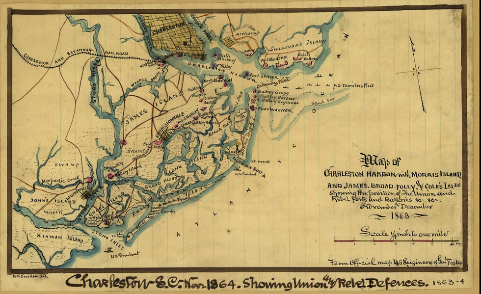
Sullivan’s Island has a long military history stretching back before the American Revolution. Historian, Nic Bulter, notes that by 1674, the first guns were placed on the island to protect the mouth of the Charleston harbor. By 1775, South Carolinians were considered a break with England and they rushed to short up old forts and build new ones in preparation for war. In 28 June 1776, Fort Sullivan (now called Fort Moultrie in honor of Col. William Moultrie), an incomplete earth and palmetto log fort, became the site of the first victory against the British, who struggled with the sandbars and tides and were pelted by the American forces at the fort.

Fort Moultrie housed army troops throughout the antebellum era, most famously Edgar Allen Poe, who was stationed there in 1827-1828. Fort Moultrie was active during the American Civil War for the Confederacy, and for the US government during World War I and World War II. It is now a historic site operated by the National Park Service and a must-see stop.

Resort Towns: Moultrieville and Atlanticville
After the American Revolution, residential development began on the island near the fort, on the western end of the island. The small village of Moultrieville was established on the island for summer residences. In 1802, John Drayton wrote that, “ in 1791, the legislature passed a resolution permitting people to build there, on half acre lots; subject, however to the condition of their being removed whenever demanded. . . it contains at present near two hundred dwelling houses, besides kitchens and out officers. This place is little resorted to in during the winter and spring; but in the summer, and autumn, numbers of people reside there, for pleasure or health, and packet boats are playing at all hours, between it and Charleston. Though most of the buildings were destroyed during the Civil War because of their proximity to Fort Moultrie and the fighting, Moultrieville had a building boom in the 1870s and still holds some of the earliest architecture on the island.

Atlanticville, another small resort development replete with residential lots surrounding the Victorian era Atlantic Hotel (previously called the New Brighton and relaunched in 1896), which burned in 1925. Atlanticville was created in 1910 by investor James O’Hear. Atlanticville is located just east of present-day Ben Sawyer Boulevard and like Moultrieville, is a National Register historic district. The area was popular for surf bathing and beach visits.
Another defining characteristic of the island are the station numbers for streets, which harkens back to Coast Guard designations. Historian, Christina Butler, notes, “The island played a longstanding role not only in coastal defenses but in maritime lifesaving, which is most visible today in the names of the Station streets across Sullivan’s. The United States Lifesaving Service, forerunner to the Coast Guard, was established on Sullivan’s Island in 1894 to protect beachgoers and residents from drowning, and boats and ships from other maritime disasters such as storms or getting caught by sandbars.”

The Twentieth Century
Before the modern bridges were constructed, residents reached Sullivan's via boats, ferries from Mount Pleasant, and by trolley cars that once brought people from downtown Charleston all the way to the beach. Vacationers enjoyed the unspoiled beaches, as did locals for day trips.

As late as the 1960s, the Army Corps of Engineers noted that, “Sullivan’s Island and Isle of Palms are summer beach resorts, and all beach frontage is privately owned. Neither has any industry, and the majority of the working population of these communities commute to jobs in Charleston.”
Sullivan’s experienced a building boom in the 1930s as the Federal Reserve area expanded, and after World War II, when Fort Moultrie was decommissioned and surrounding lands were conveyed to Sullivan’s Island Township Commission for sale and development. After nearly two centuries of public ownership, residents could hold title to their own properties in 1953, and many families stationed previously on the island decided to stay and build during the baby boom era.
Living on Sullivan's Island
Sullivan’s is a self-supporting town with its own library branch in a reused historic gun battery building, churches like Stella Maris Catholic Church, a rare stone building designed by local architect John H. Deverux and begun in 1869, schools, parks, beach access, shops, Battery Gadsden Cultural Center that “shares the rich history of the island through lectures and performances”, and bars and restaurants.

The civic center on Middle Street has a state-of-the-art fire station and EMS, town hall, and Stith Park with tennis courts, playgrounds, and a soccer field. The island is very safe and very family friendly. Thompson Park along the beach is a popular dolphin, porpoise, and sea turtle watch spot. Provisions include Home Team, Mex 1 Cantina, Sullivan’s Fish Camp, the Obstinate Daughter (James Beard award-winning eclectic fare), Poe’s Tavern, The Longboard, and Dunleavy’s Irish Pub.

The island’s sought after housing stock includes historic beach cottages that are protected by a dedicated Design Review Board and sprawling, beautiful new beach houses and cottages that incorporate the island’s traditional architectural character such as light colors, beadboard and shiplap interiors, houses sited for optimum breeze and views (a must before air conditioning), and wide porches.
--
For more insights, market updates, and tools to elevate your business, follow CHS Regional MLS on Facebook and Instagram. Not a member yet? Join today for exclusive access to the Lowcountry’s most comprehensive, accurate, and up-to-date property database.
Sources:
https://www.ccpl.org/charleston-time-machine/sullivans-island-property-crown-and-state
https://www.ccpl.org/charleston-time-machine/surf-bathing-sullivans-island-19th-century
https://www.ccpl.org/charleston-time-machine/florence-osullivan-south-carolinas-irish-enigma
Butler, Nicholas. “Quarantine in Charleston Harbor.” https://www.ccpl.org/charleston-time-machine/quarantine-charleston-harbor-1698-1949
Gadsden Cultural Center. Sullivan’s Island. Charleston: Arcadia Publishing, 2004.
Miles, Susannah Smith. The Islands: Sullivan’s Island and Isle of Palms, an illustrated history. Charleston: Ross Printing, 2013.
National Register, Moultrieville Historic District.
National Register, Atlanticville Historic District.
Historic maps and plats