Discovering Awendaw South Carolina: A Guide to Waterfront Living and Natural Beauty
- CHSMLS
- Jun 4, 2025
- 5 min read
Located beyond the sprawl of Mount Pleasant and surrounded by national forests and protected coastlines, Awendaw South Carolina takes pride in its rural setting and small-town character.
Awendaw South Carolina History & Overview
The town is situated along Highway 17 between Wando and McClellanville in a Lowcountry stretch of Charleston County. It was historically a fishing and crabbing town and keeps that heritage alive today.

Awendaw was named by the Sewee indigenous tribe who were the first known occupants of the area. The name is thought to translate to “red clay." The Sewee left behind an oyster shell midden or mound that is a reminder of their largest settlement site, which is listed to the National Register for its importance. The shell rings are visible along a hiking trail and are believed to be an ancient trash deposit begun by pre-Columbian inhabitants that was probably in use for hundreds of years. The natives called their settlement Wappetaw, meaning “sweet water.” The present town was created in 1696 by settlers from Salem, Massachusetts, who fled south after the Salem Witch Trials. The Salem founders of the current town were “dissenters” who were not members of the Church of England (the state-backed religion in colonial South Carolina) and formed their own Independent Congregational Church by 1700 (no longer extant, though the graveyard survives). Wappetaw was renamed Awendaw officially after the American Revolution in 1783.

Awendaw has a strong rural heritage. It was home to rice plantations alongside saltmarshes for most of the nineteenth century. Tibwin was created by the Collins and Matthews family in the colonial era and retains a later historic house that can be viewed via the South Tibwin Hiking Trail. Two Cedar was home to the Boyd, Swinton, and Whilden families. Walnut Grove was established by the Doar family and is now part of the National Forest. The Pepper Tract, now gated equestrian community, lies just south of Awendaw proper and was used as timber land after the Civil War.

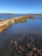
Residents and visitors have always loved Awendaw for hiking, biking, boating, hunting, and swimming on the lakes, rivers, creeks, Bull’s Bay, and the adjacent open ocean. The combination of fresh, salt, and brackish water means a diverse bounty of fish, oysters, and shrimp that have been Lowcountry dietary staples for centuries. Locals are aware of tidal fluctuations and the water temperature during different times of the year, which impact what types of fish are in the waters. Summer is the best for ocean fishing, but since the Lowcountry is subtropical, there isn’t a true off season.
The Francis Marion National Forest boasts 260,000 unspoiled acres in which there are plantation houses, trails, marshes, thick woods, and swamps (it is named for Revolutionary War hero Marion, the “Swamp Fox”, who terrorized the British with his guerilla tactics). The Awendaw Greenway has a three and half mile trail in the center of the town. The adjacent Sewee Visitor and Environmental Education Center highlights the areas Native American history and offers programs on the rich flora, fauna, and local ecology.

Cape Romaine National Wildlife Refuge and Bulls Island include 66,000 acres of protected coastal landscape that can be accessed by kayak or by Bull’s Bay Ferry operated by the expert guides of Coastal Expeditions. Cape Romaine Lighthouse, built in 1853 to replace an earlier building, is the focal point on the coastline when approaching the preserve from the ocean. Lightkeepers lived on site and manned the Fresnel lens light until the 1930s, when Lighthouse Island, Cape Island, Raccoon Key, and the surrounding marsh became the Cape Romain Migratory Bird Refuge, which has grown to include adjacent Bulls Island. Stephen Bull claimed the island in 1670 as the English arrived in South Carolina and became its namesake. By 1925, it passed to U.S. Senator Gayer Dominick, who built the Dominick House on the island and used it as a winter retreat; he ultimately donated the land for conservation, and the house is now the center of the picnic area next to the ferry landing. Bulls Island has an expansive beach, a “boneyard” of driftwood, miles of hiking trails. There are alligators, dolphins, and sea turtle sites galore as well as 300 species of birds.

Awendaw has so many outdoor amenities. The town hosts the Blue Crab Festival every August, which was started by the town’s first mayor, William H. Alston (serving from 1992 to 2009) and his wife Minnie. Awendaw Green “a hidden gem and safe haven for all original musicians”, is a “laid back venue in a laid-back town” that highlights local and regional performers. The live outdoor music venue hosts Barn Jams and various concerts on site and sponsors a Wednesday night music scene at Sewee Outpost.

Most residents do their shopping in nearby Mount Pleasant, an easy commute down 17, but the Sewee Outpost in Awendaw has folks covered with quick convenience shopping, locally made snacks and groceries, fishing gear, bait, outdoor goods and gear including Carhartt and Columbia Sportswear, and gas. The Outpost also has an in-house kitchen that serves fresh biscuits and sandwiches, and a freezer with local meat and vegetables.

Seeing the writing on the wall of greater Charleston growth, Awendaw incorporated in 1992 to be able to control their own destiny. They have an elected council government system, but do not have public water and sewerage for the roughly 1,100 residents who know that public systems will bring rampant development. Awendaw’s real estate is limited since it is a small town that wants to stay that way, but there are water lots and inland lots to build a dream home, as well as beautiful custom-build houses grouped near 17 and in Woodville community. Most of the houses currently on the market were built in the last ten years or so, in a traditional Lowcountry style.
--
For more real estate resources, follow CHS Regional MLS on Facebook and Instagram! If you’re not a member yet, join CHS Regional MLS for access to the Lowcountry's most extensive and accurate property database.
Sources:
Historic maps and plats
National Register of Historic Places, Sewee Shell Mound (designated 1970).
SC Picture Project, Awendaw entry
Christina Butler. “Historic Sites and Recreation East of the Cooper.” Charleston Empire Properties. 2023.
Moultrie News. “There’s more history in Awendaw than meets the eye.” 25 January 2011.